Posts

MAP Rain model infographic

MAP Rain model infographic shows some of the analytics solutions built using the MAP Rain model

MAP Rain is a generic real-time model built using MAP for processing, primarily, radar and forecast rainfall data. The model delivers all the underlying process of fusing the historic, current, Hyperlocal (our own 1-hour forecast) and forecast rainfall data together for any area, resolution, or size of cutout (the area over which we process the rainfall data). Built into MAP Rain are lots of methods to re-sample, aggregate, extract and re-process the rainfall data. These ensure we have the flexibility to apply rainfall data to any point or polygon in the overall cutout area. All these methods are available as API calls.

We use MAP Rain to build a broad range of applications that have rainfall data at their heart. The number of such applications continues to rise and we can deliver all these applications to multiple customers on one instance of MAP.

MAP Rain Infographic

More information on MAP Rain

Current Hyperlocal Storm alerts

These are the Hyperlocal Storms alerts (beta) identified around the UK for today. Using real-time radar rainfall we are tracking the path of areas of high-intensity rainfall and predicting their movement over the next hour, at 5-minute increments, using a machine learning algorithm. As these Hyperlocal Storms pass over any village, town or city we generate an alert. For customers interested in particular cities then we can create the alerts for any postcode sector in the city.

This is part of our MAP Rain service. For more information then click here.

We have created our own Hyperlocal Rainfall predictions for the past 5 years. Click here for more information and you can download the Hyperlocal Rainfall app on both the Google Playstore and the Apple App Store.

MAP Rain – Updates in the Works

Section 19 Investigation Information

MAP Rain is our high performance, flexible and scalable cloud-based solution for rainfall and flood monitoring analytics. MAP Rain delivers location specific rainfall analytics for any point and any area of interest.

MAP Rain – Analytics for Flood Investigations

Download the Hyperlocal Rainfall App on Android and iPhone

Meniscus Systems have officially released the Hyperlocal Rainfall App onto iTunes. Users can now download the app on: Android – Google Play iOS – iTunes The simple-to-use ‘Hyperlocal Rainfall’ App uses GPS location for point-to-point journeys, to provide highly-localised rainfall predictions for imminent time-windows, allowing users to plan their journeys. Using the App allows them to undertake […]

Flood Forecasting part 2

A new project has been undertaken by several UK Councils using MAP to deliver specific localised flood monitoring and is currently being tested by Cambridge City Council.

Flood forecasting

Flood forecasting

This service combines actual radar rainfall and forecast rainfall data and uses it to calculate the maximum rainfall return period for a specific location for the next 36 hours as well as the Antecedent Precipitation Index (API) as an indicator of moisture levels in the soil (this calculation uses soil type data).

The solution also displays river level gauging data from the Environment Agency and the historic and forecast information is displayed in a mobile-friendly dashboard. The next stage in this project is to implement a learning based model to correlate increases in these rainfall metrics with the increases in the river gauging height.

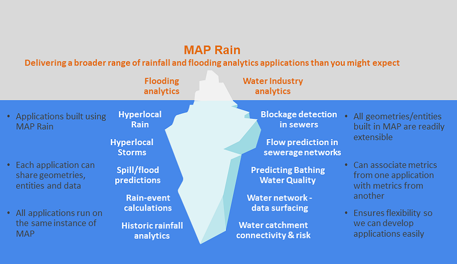
All the above working examples demonstrate some of the capabilities of MAP in terms of integrating a broad variety of datasets into models built inside MAP as well as the capability to use MAP to deliver aggregated datasets into third party models run externally to MAP.

MAP makes extensive use of RESTful Web Services making it possible for approved third parties to easily load new datasets, create new Entities and extract aggregated/calculated datasets from MAP. An Entity is any unique identifiable “Thing” which in this context might be a community, a property, a catchment etc. Each Entity contains internal ‘hooks’ to the calculations/models required to turn any raw dataset into the required calculated metrics. MAP provides the framework to allow these Entities to be readily extended making it easy to change the underlying models/calculations and adding in new database properties and metadata.

It is also envisaged that MAP will use additional datasets to enhance the capabilities of existing models and potentially use these to improve the inputs into current models. These additional datasets might include:

  • Satellite based imagery. MAP already has the capability to process images into gridded datasets and this is already used to capture soil type information. Such imagery might improve estimates of permeable/impermeable contributed areas to name one such use.
  • Topological data or potentially LIDAR data to improve the topographical data fed into models.
  • Using data from third party weather stations to include companies who operate a network of weather stations providing soil moisture sensors at various depths, humidity and evaporation sensors. Meniscus is already looking to integrate such data.

It is envisaged that a final solution may comprise an enhanced mobile app and associated mobile friendly dashboard delivering location specific flood information derived from this broad range of datasets. Importantly this flood information will use machine learning to improve flood predictions based on the relationship in the actual data and will not rely upon complex deterministic models – unless they are already available.

How Innovative is MAP for Predicting Flooding?

Predicting Flooding

Predicting Flooding

Flood Prediction

Existing solutions for predicting flooding are heavily reliant on the use of complex models that are very expensive and time-consuming to build. In addition, these models can be too complex to readily run in real time conditions.
The Meniscus approach looks to replace this by using existing datasets and models wherever possible to build up simplified models that can be run in real time.

These simplified models can then be improved upon using a combination of machine learning and by using additional datasets (like satellite imagery) to improve the assumptions and variable on which the models are built. Consequently, this approach is ideal for delivering real-time flooding information for a large number of relatively small catchments (it is assumed that the existing more complex models will cover known flooding hotspots).

The use of the algorithms already developed in MAP to track existing rainfall and predict its course over the next hour will enable the solution to rapidly respond to the development of short summer high-intensity rain events rather than relying on forecasts that are notoriously poor at forecasting such events.

MAP itself is a new and highly innovative platform (the development was initially part funded by InnovateUK in 2014) and its structure is specifically developed to allow rapid development and changes to the underlying database structure and models. It is cloud based with a comprehensive RESTful web service interface making it possible for third parties to interact with it.