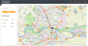
UK map of consented discharges to rivers and groundwater
MAP of consented discharges to rivers – beta version
Overview
We have created a map showing the location and details of all consented discharges to rivers and groundwater for England. We are planning to extend this to both Wales and Scotland if we can obtain the consent data in a suitable format from Natural Resources Wales and SEPA.
The map shows all main UK rivers and the location of any consented discharge to both rivers and groundwater. Also included are the locations of all Combined Sewer Overflows (black icon) in England. For all consents (orange icon) where the discharge is to river, then we have added the expected location of the consented discharge into the river (blue icon at the end of a green line).
The map will use your current location (subject to you granting access) to display relevant data. For access on a mobile phone then the area you can view is limited to ensure the site loads quickly. On a PC then you can access a larger area.
Purpose
The idea for the site arose during the Big Rivers challenge at the Northumbrian Water Innovation festival. Meniscus were part of a team, including Meniscus, ESRI and NWL employees to develop a prototype app for Open Water swimmers to understand risk from pollution events. Whilst a lot of the data to deliver such an app is currently not available as a public dataset, we have created this dashboard as a first step to allow river users to identify discharges into rivers.
Information your would like to see
Please let us know if there is additional information that you would like us to try and include in the map. We cannot promise to make changes but we will always look to see what can be done.
Contact us at [email protected] or through our contact page
Background on MAP Rain
More information on MAP Rain click here

