MAP Rain – rainfall map and analytics for urban areas

We are pleased to announce the introduction of a new geometry in MAP RAIN that delivers big cost reductions. This is ideal for large rural agencies who want a rainfall map and rainfall analytics data for their urban areas.

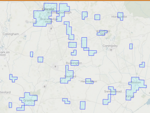
A new Multi-Polygon geometry delivers a rainfall map for just the areas that area of specific interest to you. Before this, we had to provide rainfall and associated data for the whole area of interest.

Click here for more information on MAP Rain and rainfall map

  • Example: A Lead Flood Authority with a large predominately rural area of say 10,000km2 only wants real time and predictive rainfall analytics and access to FEH data for the urban areas, say 750km2. Previously, we had to provide rainfall data for the whole 10,000 km2 area and then add Polygons within this for specific catchments of interest. With the new Multi-Polygon geometry we can provide the customer with these analytics for JUST the urban areas. This delivers a big reduction in the cost of accessing rainfall analytics information from MAP Rain. I.e.MAP Rain prices are based on 750km2 rather than 10,000km2.
  • Example of multi-polygon area

    To receive a quote for using MAP Rain in your are then please send us a message from the Contact Page