Hyperlocal Rainfall – delivering location specific rainfall predictions every 5 minutes for the next hour
What is Hyperlocal rainfall?
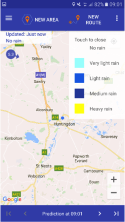
Hyperlocal Rainfall is an add on to our core MAP Rain solution. Using the latest radar rainfall data it predicts the path of the every rain call (1km x1km) every 5 minutes for the next hour. When new radar rainfall arrives (which is every 5 minutes) it creates another set of predictions so you get the most accurate and up to date predictions possible.
Hyperlocal Rainfall app
This is a FREE app available to any user.
Don’t get caught in the rain! Hyperlocal Rainfall delivers accurate real time rainfall predictions personalised for the journeys and areas you create. Our data is updated every 5 minutes and we predict where and how intense rainfall will be at 5 minute intervals for the coming hour.
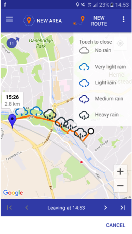
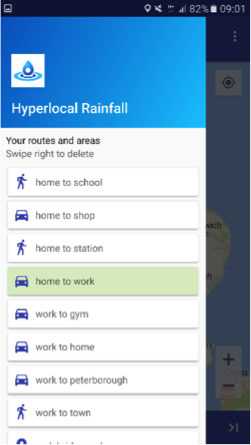
This is the first app to provide hyper-localised rainfall information whilst on the move, along your exact route or specific area. Create your journey and choose if you would like to walk, cycle, or drive and the rainfall predictions will appear along that route showing you what the conditions will be when you get to that point of your journey. Use the app to avoid rainfall by showing predictions if you change your journey start time.
The aim is to provide accurate and personalised information for users so they can make informed decisions and be more confident about choosing sustainable travel options
Hyperlocal is still considered to be in its beta version and Meniscus would welcome any feedback – even if it’s negative! Any feedback will allow us to continue the improvement of Hyperlocal Rainfall. Use the following link to download Hyperlocal Rainfall for free now.
Hyperlocal Rainfall app for Android
Please note that the Hyperlocal Rainfall app requires a Google login account to improve the accuracy of the predicted rainfall along your Journey.
This project was part funded by InnovateUK as a consortia based industrial research Smart City project. Our partners in this were Loughborough and Anglia Ruskin Universities and Peterborough Environment City Trust.
Hyperlocal Hotspots
For app users, Hyperlocal Hotspots are areas (or geofences) around an area or a location that can display a specific logo in the app. This allows City Councils who support the use of Hyperlocal Rainfall to brand the app with their logo.
For API users, Hyperlocal Hotspots are created for specific customers and are used to limit API access to Hyperlocal Rainfall to specific areas (or geofences).
Corporate access
For companies wanting to provide access to rainfall predictions to their workforce, using Hyperlocal Hotspots we can provide a company specific area accessible only to approved users in your organisation. Users login with their own business e-mail address which we authenticate to approve the user.
Benefits to companies
- Health and wellbeing of employees: Hyperlocal Rainfall can be part of an overall programme to encourage employees to cycle to work
- Improvements to work planning: Hyperlocal Rainfall can help them plan their work around the weather so they have a much better idea when rain will actually impact on their location
API Access
Hyperlocal Rainfall data is available to developers via the MAP Hyperlocal RESTful API that allows developers to integrate rainfall and predictions directly into their own systems. Using the API you can:
- Create Journeys and Areas
- Create Users
- Download actual and predicted rainfall for a Journey or Area
Example 1
Returns Rainfall Intensity (mm/hr) at a specific location for the next hour
Example 2
Returns Rainfall Intensity (mm/hr) at a number of locations – times are in 5 minute offsets from NOW
Techie stuff
MAP
The Meniscus Analytics Platform (MAP) is a high performance, flexible and scalable cloud based analytics platform. It was developed around our 15+ years experience in delivering web based analytics and built for real-time processing of large data sets. MAP’s scalability allows it to deploy a solution for hundreds of thousands to millions of ‘Things’ whilst its flexibility allows properties and metadata to be added dynamically allowing an application to develop as its needs change. Finally the power of MAP delivers lightning fast calculation speeds to deliver analytics on demand – in terms of Hyperlocal Rainfall MAP is processing 150,000,000 raw data points a day whilst delivering 100,000 predictions a second.
Prediction accuracy
We are committed to continually improving the accuracy of these predictions over time and to this end we are adopting a number of techniques. For each Journey we also store the actual rainfall for that Journey against our predicted rainfall so that we can compare and measure the improvement in accuracy over time.
Local wind data
Initially Hyperlocal Rainfall combined various data sets to provide its predictions including local wind data obtained from various wind stations around Peterborough (around 21 stations). Whilst this data worked well when Hyperlocal started, as it was initially a project specifically for Peterborough, it was not sufficient or sustainable for the whole of the East of England or indeed the whole of the UK.
High Altitude wind data
Hyperlocal has progressed from using Peterborough wind data to using high altitude wind data for the whole of the UK. This is forecast wind data that is more accurate than ground wind data due to the fact that the clouds may move in one direction, while the below ground wind data would suggest it is moving in the opposite direction. Therefore by using high altitude wind data the tracking of rainfall data becomes more accurate which improves the Hyperlocal predictions.
Cell tracking
In the medium to longer term, Meniscus aims to track every individual pixel of rain at 1km2 resolution to track the direction and velocity so that we can become less reliant on a forecast wind data set. This in turn will make the predictions much more dynamic to local conditions.
Ground-truthing
The principle of ground-truthing is to compare the radar rainfall data with accurate ground based weather station data and to make small adjustments to the radar data so that it more accurately matches the weather station data. This involves implementing the Marshall-Palmer Z-R relationship between radar reflectivity and actual rainfall data, Z and R respectively.
Ground-truthing is a complicated process despite its seemingly simple equation. We are currently looking to further improve our Ground-truthing efforts by carrying out more regular and automated zonal ground truthing. Additionally our current attempts at this are using a static (whole period based) relationship. Our final objective is to move to dynamic (event based) re-calibration.
Privacy Policy for Hyperlocal Rainfall
Privacy Policy
Click this link for a copy of our Hyperlocal Rainfall Privacy Policy


