MAP Rain case study – Leeds City Council and storm Ciara
Case Study overview
Leeds City Council use MAP Rain to analyse historic rain events and to receive forecast rain alerts. This is a summary of the alerts generated for storm Ciara on the 9th and 10th February 2020 and compares actual rainfall against the alerts generated.
MAP Rain supports different type of rainfall alerts. The alerts for Leeds include:
MAP Rain constantly reviews and calculates these alerts every 5 minutes as new radar and forecast rainfall data is received. E-mails are sent to the Flood Management team according to a set of rules designed to limit the number of e-mails sent.
Over the last two years, the Leeds City Council Flood Management team have been very pro-active in reviewing and adjusting these threshold values in light of historic flooding events. They have also adjusted the location of the monitoring points to correlate them more precisely to locations at risk.
Quote from John Bleakley Group Engineer (Investigations) on the 18th Feb 2020.
“One of the big successes from a surface water flooding impacts perspective (not river) for me was Meniscus after lots of tweaking. For Ciara we had hundreds of Meniscus warnings and they were pretty much spot on from where I sit, which means we can galvanise our efforts in those areas with more confidence in the future, contrast storm Dennis a week later, there were hardly any Meniscus rainfall alerts for our district which again, was borne out in reality by no flooding impacts in the Leeds District.”
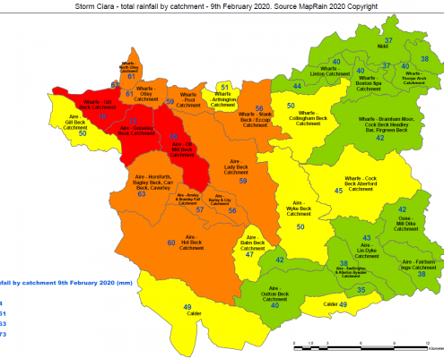
Actual rainfall depth – issued by Leeds City Council flood team on the 10th February
The choropleth map shown below was created by the Leeds City Council flood team the day after the event using data from MAP Rain. The image was tweeted to residents the day after the storm and is a great example of the use of maps to communicate the location and depth of the rainfall that affected the community.
MAP Rain FEH rain event Alerts
For storm Ciara, MAP Rain generated alerts for 5 catchments and 18 monitoring points. These alerts were e-mailed to Leeds City Council and latest alert status was displayed on the MAP Rain dashboard.
Alerts for the monitoring points were generated earlier than the catchment alerts and also changed more frequently. This is a consequence of the inherent averaging associated with the catchment alerts. The catchments aggregate the rainfall for all the underlying rainfall cells and this averaging, or smoothing, means they react slower to changes in the forecast rainfall.
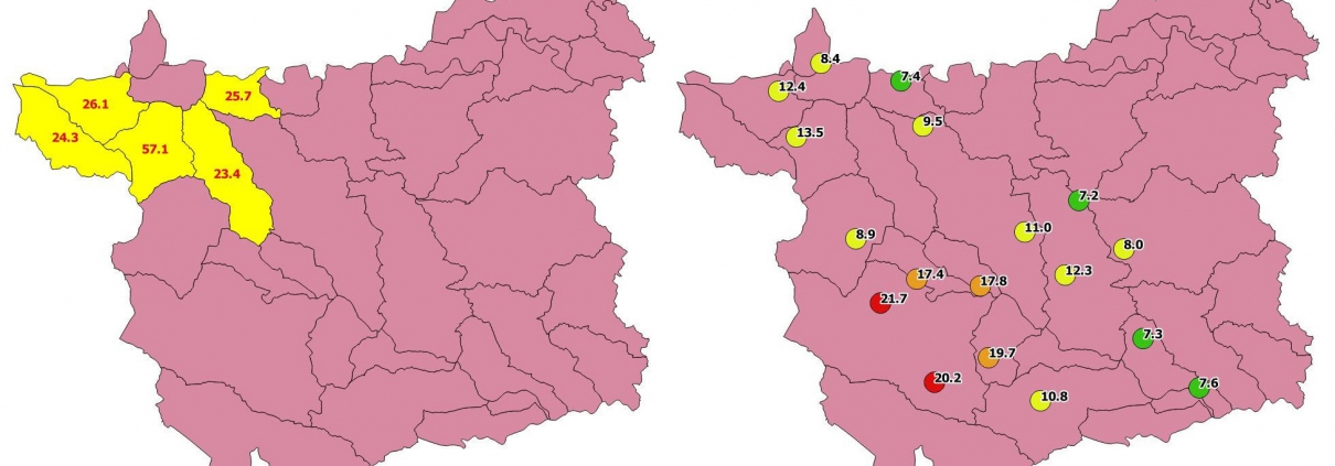
The two images below display the results for the first FEH Alerts generated for the storm. The left-hand image shows the first catchment alerts (shown in yellow). The right-hand image shows the first point-based alerts with their corresponding colour coded legend. The numbers are the calculated FEH rain event predicted for the catchment or point.
The first monitoring point alerts were generated at approximately 09:45 on the 8th February with the majority generated from about 20:00 on the 8th, some 4-5 hours before the start of the heavy rain.
The first catchment-based alerts were created later at about midday on the 9th February.


